
Station Guide
View information on where to board your bus.
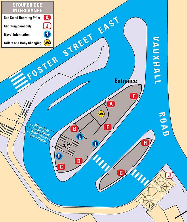
Below is a guide to Stourbridge Interchange situated in Foster Street East, showing the location of bus stands and which servcies depart from which stand.
A majority of bus services also stop at the bus stop situated in Bath Road (on Stourbridge Ring Road), which is located opposite the Crystal Lesuire Centre / Tesco Extra Supermarket.
A majority of bus services also stop at the bus stop situated in Bath Road (on Stourbridge Ring Road), which is located opposite the Crystal Lesuire Centre / Tesco Extra Supermarket.
Interchange Stand Plan
| Service | Destination | Operator |
 Stand A
| 88 |
Norton
via Oldswinford | Stourbridge Junction | Pedmore | Lea Vale |

|
|
| 142 |
Halesowen
via Stourbridge Junction | Wynall | Fatherless Barn |

|
|
| 142 |
Halesowen
via Stourbridge Junction | Wynall | Fatherless Barn |
|
|
| 142A |
Halesowen
via Stourbridge Junction | Wollescote | Fatherless Barn |
|
|
| 142A |
Halesowen
via Stourbridge Junction | Wollescote | Fatherless Barn |
|
|
| 318 |
Bromsgrove Railway Station
via Hagley | Clent | Belbroughton | Catshill | Bromsgrove |

|
|
Stand B
| 25 |
Dudley
via Withymoor Village | Merry Hill Centre | Netherton |
|
|
| 142 |
Merry Hill Centre
via Wollaston | Brockmoor | Brierley Hill |
|
|
| 142 |
Merry Hill Centre
via Wollaston | Brockmoor | Brierley Hill |
|
|
| 142A |
Merry Hill Centre
via Wollaston | Brockmoor | Brierley Hill |
|
|
| 142A |
Merry Hill Centre
via Wollaston | Brockmoor | Brierley Hill |
|
|
| 242 |
Kinver
via Wollaston | Stourton |
|
|
Stand C
| 16 |
Wolverhampton
via Amblecote | Wordsley | Kingswinford | Swindon | Wombourne |
|
|
| 17 |
Dudley
via Amblecote | Ashwood Park | Kingswinford | Gornal Wood |
|
|
| 17A |
Dudley
via Amblecote | Wordsley | Kingswinford | Gornal Wood | Stickley | Milking Bank |
|
|
Stand D
| 8 |
Wolverhampton
via Merry Hill Centre | Dudley | Coseley |
|
|
Stand E
| 7 |
Dudley
via Pedmore Fields | Lye | Merry Hill Centre |
|
|
| 25 |
Kidderminster
via Norton | Broadwaters Heath |
|
|
Stand F
| 6 |
Dudley
via Amblecote | Brierley Hill | Russells Hall Hospital |
|
|
Stand G
| 7 |
Wollaston Junction (Village)
via Norton | High Park |
|
|
| 8 |
Wollaston Farm
via Wollaston |
|
|
Stand H
| 9 |
Birmingham City Centre
via Lye | Halesowen | Quinton | Bearwood |
|
|
 Stand J
|
|
 Platform 1
| Rail | Stourbridge Junction |

|
Local Area Maps
View local area maps.
Below are links to the local area map for Stourbridge area, which is a part of the TfWM Sandwell and Dudley area map, showing details and routes of Stourbridge bus services.
Looking for further afield? Click on the Link below to take you to the Transport for West Midlands website page where maps for other areas in the West Midlands are available.
Looking for further afield? Click on the Link below to take you to the Transport for West Midlands website page where maps for other areas in the West Midlands are available.